Evacuation Orders
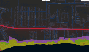
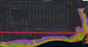
- An evacuation order, effective at 12:30 p.m. on Thursday, October 8, has been issued for Zones A and B, low-lying areas and mobile homes in Santa Rosa County. Don’t wait, evacuate! Evacuation only needs to be tens of miles, not hundreds, to be safe.
- Know Your Zone! Visit Santa Rosa County’s for evacuation zone information. Zones A and B are the orange and red ares on the evacuation map and generally include areas on/close to water (Navarre Beach, Blackwater River, Escambia Bay, East Bay, etc.)
Shelter
The Clyde L. Gracey (Milton) Community Center, 5629 Byrom St. in Milton, will open at 8 a.m. on Friday, October 8, as a shelter for residents who want to evacuate or do not feel safe in their homes. No pre-registration is required.
This shelter is also a pet-friendly shelter. Bring pet(s) in a carrier with proof of vaccinations and all pet food and supplies, including water, leashes and/or litter boxes with litter.
Shelters are usually uncomfortable. Meals are not provided. It is recommended that other arrangements be made to stay at a hotel or with a friends or family in a well-constructed home that is properly protected to withstand hurricane-force winds.
Anyone needing transportation assistance to a shelter should call (850) 983-4636. Transportation will only be provided if winds are below tropical storm force (so call early) and will only take you to a designated shelter.
Bring the following items:
- Personal identification
- Water, non-perishable snacks and any special dietary needs.
- A change of clothing, rain gear and sturdy shoes.
- Toiletries and personal items.
- Blankets, pillows and sleeping bags.
- Games or toys for children; books for adults.
- Special items for infants or elderly family members.
- Battery-operated radio, flashlights and plenty of spare batteries.
- Prescriptions or any over-the-counter medications you normally need.
Key messages
- Santa Rosa County Emergency Management has declared a Local State of Emergency, .
- Governor Ron DeSantis has issued a State of Emergency with Executive Order 26-202, .
- A hurricane warning is in effect for Santa Rosa County and a Storm Surge Warning is in effect for the coastline.
- Santa Rosa County is under a Flood Watch from 1 p.m. Friday, October 9 through 1 p.m. Saturday, October 10.
- Hurricane Isaias is forecast to continue to strengthen over the next 24-36 hours, possibly approaching major hurricane strength while over the central Gulf. Isaias is forecast to make landfall somewhere along the northern Gulf Coast Friday night into early Saturday morning. While the storm is not expected to make landfall at peak intensity, it is likely that Isaias will still be a significant hurricane when it reaches the coast.
- Significant impacts are likely. Impacts include damaging winds, life-threatening storm surge, high surf, rip currents, flash flooding, and tornadoes.
- The greatest wind damage risk is along coastal areas. However, given the fast movement of the storm, the potential for strong, damaging winds also extends inland.
- There is potential for: Considerable roof damage; mobile homes damaged; many large trees snapped or uprooted along with road signs blown over; some roads impassable due to debris; large areas of power outages.
- There is an increasing risk for tornadoes Friday night into early Saturday morning. The greatest risk for tornadoes will exist for areas north and east of where the center of Isaias tracks (within any heavier rain bands). Have multiple ways to receive weather warnings!
- There is a potential for flash flooding. Residents should prepare for: Flooding of some structures, especially in typical vulnerable locations; rapid inundation at underpasses, low-lying spots, and poor drainage areas in some places; hazardous driving conditions; water flow over streets and parking lots as storm drains and retention ponds overflow.
- The extent of the heavy rain will highly depend on the exact track.
- Turn around, don’t drown! Never cross a flooded roadway because you can’t see whether the road has been damaged.
- Those living in areas prone to flooding should be prepared to quickly move to higher ground if warnings are issued.
- A high rip current risk is in effect for Navarre Beach through at least Saturday, October 10. Rip currents can sweep even the best swimmers away from shore into deeper water. Always swim near a lifeguard.
Sand
The county’s public works department has sand available on a first-come, first-served basis at the following locations:
- The corner of Leisure Street and Citrus Drive in Navarre
- Tiger Point Park in Gulf Breeze (1370 Tiger Park Lane)
- Pace Fire-Rescue in Pace (4773 Pace Patriot Boulevard)
- The corner of Pine Forest Road and Carroll Road in Milton
Residents must provide their own sandbags and shovel. Bags can be purchased at many local hardware stores. For information on how to make and use sandbags, visit the (). While sandbags can help mitigate to an extent, buying flood insurance is the best protection against flood loss.
Floods are the nation’s most common and costly natural disaster and cause millions of dollars in damage every year. And get it sooner rather than later – flood insurance requires a 30-day waiting period.
Cancellations
- The Library Advisory Board Meeting is cancelled for Thursday, October 8 at 11 a.m. at the Library Administration Center/Family History & Research Center, 6275 Dogwood Drive in Milton.
- Household Hazardous Waste (HHW) Amnesty Day at the South Santa Rosa Service Center and Waste Tire Amnesty Day at the Central Landfill in Milton are cancelled for Saturday, October 10.
- Santa Rosa County Animal Services has cancelled the Fall Fest Adoption Event originally scheduled for Saturday, October 10.
Santa Rosa County Offices
- Santa Rosa County Offices will be closed Friday, October 9.
- Santa Rosa County Libraries will close at 4:30 p.m. Thursday, October 8 and remain closed through Saturday, October 10.
- Santa Rosa County Animal Shelter will be closed on Saturday, October 10.
- All facility reservations for Friday and Saturday have been canceled. Those with reservations on Sunday have been notified that their events may also be canceled pending storm damage assessments.
- The Central Landfill in Milton is closed on Saturday, October 10 and is expected to reopen on Monday, October 12.
- Navarre Beach Pier will be closed Friday, October 9 and Saturday, October 10.
Santa Rosa County Clerk of Court and Comptroller
- The Clerk of Court offices in Santa Rosa County will close at 2 p.m. on Thursday, October 8 and will remain closed Friday, October 9. Normal operations are expected to resume on Monday, October 12.
Santa Rosa County District Schools
- Out of an abundance of caution, all schools and district offices will be closed on Thursday, October 8 in addition to Friday, October 9. This includes athletic events, practices, clubs, meetings, and other school-sponsored activities.
- All after-school and extracurricular activities scheduled for Thursday, October 8, are canceled.
- All district and school-sponsored activities scheduled for Saturday, October 10, are also canceled.
- As a reminder, Monday, October 12, is a Planning Day and there is no school for students that day.
Santa Rosa County Property Appraiser
- The Property Appraiser’s offices in Santa Rosa County will close at 2 p.m. on Thursday, October 8 and will remain closed Friday, October 9. Normal operations are expected to resume on Monday, October 12.
Santa Rosa County Supervisor of Elections
- Supervisor of Elections- The South Service Center Office (Annex) in Gulf Breeze will be closing at 2 p.m. on Thursday Oct. 8. The Main Office in Milton will remain opened until 4:30 p.m. and will be closed on Friday, Oct. 9.
Santa Rosa County Tax Collector
- All offices of the Tax Collector will be closed beginning at 1 p.m., Thursday, October 8 and remain closed Friday, October 9. The office will also still be closed on Monday, October 12 for staff training.
Courts of the First Judicial Circuit in Santa Rosa County
- In anticipation of inclement weather, the Courts of the First Judicial Circuit in Santa Rosa County will close at 2:30 p.m. on Thursday, October 8, and will remain closed all day Friday, October 9.
City of Milton
- City Offices: All City offices will be closed Friday, October 9.
- Community Center: All activities are cancelled beginning at 4:30 p.m. Thursday, October 8.
- City Parks: All City parks will close Friday, October 9, and remain closed until further notice.
- Sanitation: Friday, October 9, sanitation collections will operate from 7 a.m. to noon. Residents should place their garbage carts curbside early and secure them immediately after collection to prevent them from becoming hazards during the storm.
- Utility Billing: Late fees on utility bills will be paused October 8–9, 2026.
- Utility Outages: Residents experiencing a City utility outage or service disruption, including water, sewer or natural gas, should report it by calling (850) 983-5420.
City of Gulf Breeze
- Normal City operations will close at NOON FRIDAY, or earlier if weather conditions warrant. The City’s Emergency Operations Center (EOC) at City Hall will be fully operational throughout the storm response.
Department of Health – Santa Rosa County
- All Florida Department of Health in Santa Rosa County (DOH-Santa Rosa) offices will be closed on Friday, October 9, 2026, in response to severe weather impacts. Offices will remain closed until further notice.
- DOH-Santa Rosa’s midway office will be closed beginning Today, October 8, 2026, and will remain closed until further notice.
- Opal Beach Complex will close for day use October 7 at Noon.
Bridges
- Bridges ONLY close when sustained tropical storm force winds are observed by FDOT or law enforcement officials. If one bridge closes, it does not mean all bridges will close.
- For state and federal road closures (I-10, Hwy. 87, Hwy. 89, Hwy. 90, Hwy. 98, Hwy. 4, Avalon Blvd.), see .
Prepare now. Make sure all family members know the plan.
- Check your disaster supply kit and replenish necessary items. Remember, be one-week ready! Review your disaster plan and make sure it includes your pets.
- Halfway full is halfway there – residents and visitors should keep their gas tanks at least half full during hurricane season to ensure they have enough fuel to evacuate as soon as possible without worrying about long lines at gas stations and to avoid gas shortages before a storm.
- Residents should make preparations now ahead of any potential impacts from Tropical Storm Isaias. Residents should have preparations completed by Friday afternoon, October 9.
- Have multiple ways of receiving alerts and monitor official sources for information.
- Clear clogged rain gutters, downspouts, and storm drains to help with the flow of water during heavy rain during hurricane season.
- Limit damage caused by high winds by removing any debris from your yard and trimming your trees, shrubs, etc.
- Every home should have a NOAA weather radio, the first line of defense before relying on alerts through a smartphone.
- Smartphone weather apps are also an excellent delivery source of severe weather information and other disaster updates – especially in the overnight hours. Santa Rosa County’s alert app – – provides updates on emergency incidents (hazardous materials as well as severe weather) in the county at addresses of your choice (work, school, home, etc).
- Be sure that you have not disabled your alerts on your phone and that it is fully charged and within reach. If you use the “Do Not Disturb” feature on your phone at night, turn it off so that any emergency calls may come through.
For current weather events, visit . For information on preparing for disasters, visit . |